
This might get confusing! For a prospective lot/house buyer, using the word “Park” in a street name infers a prestigious image and appeal.
On the early street maps of Bexley, the street “Parkview’ is shown as two words, “Park View”. The road was placed at the top of the slope overlooking Alum Creek to the west. It was intended to be one of the most important, if not the most important, street in the Bullitt Park Addition.
There was a major difference between the “view” of the park/open space westward along North Park View and the “view” of the park/open space on South Park View.
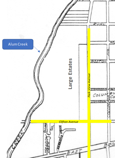
The early buyers along North Park View – the Jeffrey and Kilbourne families – sought to create large country estates on expansive grounds. Their purchase of lots that extended westward from North Park View all the way to Alum Creek assured them of having a “view” of the park/open space because they owned the land.
Along the west side of South Park View (south of East Broad Street), the original Bullitt Park Addition plat created lots – served to the rear by an alley called Westland – that undoubtedly also had views of the sloping ground westward to Alum Creek.
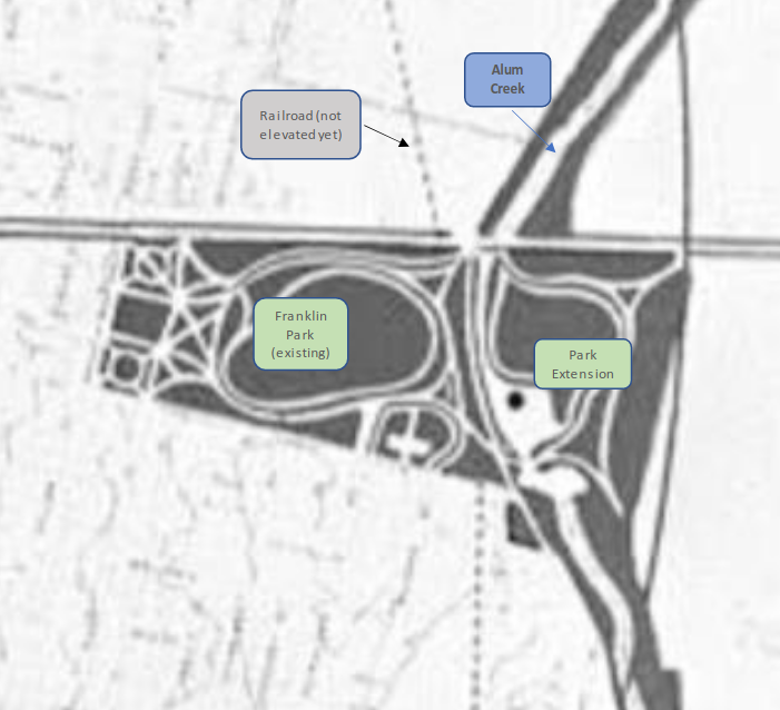
In response to a nationwide “City Beautiful” movement, Robert Wolfe led a 1908 City of Columbus Parks Plan that recommended the preservation and creation of major park spaces along the region’s rivers and streams – including Alum Creek.
For the east side of Columbus, the plan recommended adding a large space to Franklin Park east of Alum Creek – burying the railroad tracks to create a seamless park with Alum Creek running through. Additionally, the plan called for acquiring additional park acreage along Nelson Road – north of East Broad Street.
You might have noticed that that the railroad tracks were, in fact, NOT buried. Doing so was far too expensive. Rather, the City opted for elevating the tracks to create a grade separation with the crossing automobile traffic – thus allowing for Nelson Road to run next to Alum Creek and separating one large park into the two parks we have today.

To achieve this plan, Wolfe procured the entire acreage east of Alum Creek up to Westland for park land and sold the “bottom” land to the City of Columbus for $1 (one dollar) – what is, today, Wolfe Park (“park extension” in image above).
Of this section, Wolfe carved off land for two prestigious residential streets – Park Drive and Preston Road, creating in effect his own “Park View”. Properties along Park Drive are among the largest in the area – but they are located within the City of Columbus city limits and not part of Bexley.
So much for the “park view” for the residents of the west side of “South Park View Avenue” in Bexley!
Robert Wolfe constructed one of the first mansions along Park Drive (fourth house south of East Broad Street – 78 Park Drive – denoted with blue star) in 1910.
So, when was the question of “Park View” vs “Parkview” resolved? That is still a bit of a mystery. No doubt, it is buried somewhere in the Bexley City Council archives. If you know how that happened, let us know!
Written by Lawrence Helman, Bexley Historical Society Trustee
Edited by Martina Campoamor, Bexley Historical Society Trustee
2022
If you have information to add to this topic, please let us know.
All comments are reviewed before posting.